

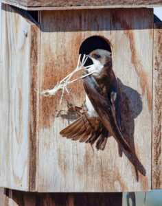


About two miles south of Davis, on the east side of Mace Boulevard, lies the South Fork Preserve. The 110-acre site includes big trees close to the creek, a younger plantation of native trees and shrubs, and a weedy grassland, all on former farmland. It has become decent habitat for birds. The eBird list stands at about 170 species, including the typical birds of willow-cottonwood associations and young valley oak woodland. In the proper seasons it is reliable for wood duck, blue-gray gnatcatcher, and Bullock’s oriole, among others. The south edge has lark sparrow and blue grosbeak. UC Davis has placed nest boxes along the trails, and monitors their success in fledging young. Tree swallow and western bluebird were the principal occupants in 2022. An attraction for birding by ear is that the preserve is less subject to the noise of motor vehicle traffic than most other destinations close to our cities.
Owned by the City of Davis, the preserve has long been open to the public, but recent improvements have made it more accessible. A formal parking lot is at the entrance, just south of the bridge over Putah Creek. Most trails begin here. Trails run the length of the preserve, roughly parallel to the creek, including a wheelchair-accessible path that leads to a handsome viewing deck along the shoreline. Note that the trail system close to the creek is incomplete. Near the bridge there is only an informal fisherman’s track, and there is no trail near the creek at the east (downstream) end of the preserve. You have to bushwhack a bit.
A perimeter trail leads away from the creek from the parking lot, along the west and south edges of the preserve, and skirts a large grassland area. There is also an informal track along the north side of the creek. To get there from the main entrance, drive (or bicycle) to the dirt pull-out just north of the bridge, rather than risk walking the narrow bridge itself. The preserve property includes a farmed area south of a tall levee that marks the edge of the floodplain of the creek. The farm property provides income for the City to use in managing the preserve.
A trail map is on the kiosk at the entrance to the preserve. My visit to the City of Davis website for “Putah Creek South Fork Preserve” yielded little information, but the Davis Wiki is some help. If you use eBird, beware that the hotspot is incorrectly called “South Fork Putah Creek Preserve.” Note also that the area west of Mace Blvd is in Solano County, and its eBird designation is “Putah Creek—Mace Blvd (SOL Co.).” Birders have managed to squeeze in yet a third eBird hotspot, “Mace Blvd bridge (YOL Co.)”, that presumably separates the other two. Enjoy!